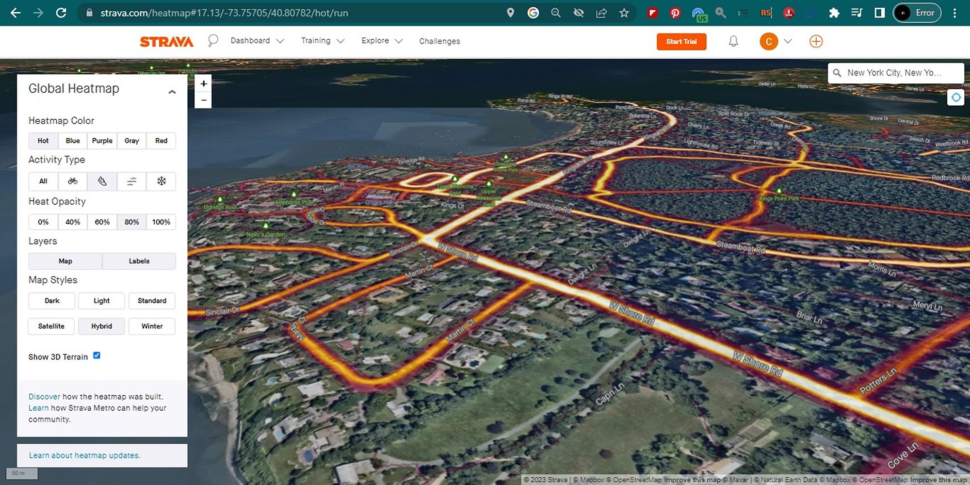
Strava, one of the most popular apps for runners and cyclists, has an interesting feature called Global Heatmap. The Strava Global Heatmap system is based on historical data from users who have uploaded their running or cycling workout data and associated GPS coordinates to the popular fitness app.
You can visualize this data in the form of colored data points or "heat maps" representing the magnitude of physical activity on a simple map. Let's take a closer look at how this works.
What Is Strava's Global Heatmap Feature?
Strava has become a social network of sorts for athletes, and it's used by millions of people every day. You can record your workouts or activities in Strava, get in shape, track your progress, and stay motivated.
Strava's Global Heatmap displays segments of commonly-traveled routes on a map that allows you to see what routes are popular for sports activities and which are not. The feature helps map point-and-area locations on a map by tracing GPS data to create a visualization of physical activity.
As a runner, cyclist, or athlete, you can use this data to uncover new insights into running performance, mountain biking skills, hiking trails, and the like. However, this data is only updated once a month, so don't expect it to be a real-time representation.
The tool can help you avoid dangerous areas by identifying them easily. To get started with the feature, you'll need to visit the Strava Global Heatmap online. You can also download the Strava app to access other helpful features on the go.
Download: Strava for Android | iOS (Free, subscription available)
How to Set Up and View Strava's Global Heatmap
Strava's Global Heatmap is designed to help you improve your training and fitness performance. To use the Global Heatmap, you need to have a Strava account. Here's how you can set it up:
- On your desktop device, go to the Strava website. Sign up for a free account if you haven't already.
-
Once you're logged in, go to the Strava Heatmap page.
- Connect your wearable fitness tracker to get more insights, as may be required.
- You can customize the map by selecting the activity type (running, cycling, swimming, or all), the heat map color, layers, and the type of visualization—dark, light, standard, satellite, hybrid, or winter.
- You can also zoom in and out of the map to see different areas or type a location of your choice to see the heat maps for that area.

Do keep in mind that this free feature is accessible only on the web version of Strava. If you'd like to view a log of personal workouts, you'll need to sign up for a subscription to access personal heat maps.
Why Would You Need to Use Global Heatmaps?

Strava's Global Heatmaps are popular tools for athletes, fitness enthusiasts, and urban planners alike. Here are some ideas for how you can use the global heat maps feature:
- It helps you find popular running or cycling or biking routes.
- It can be used to analyze athletic performance by overlaying a user's data onto the heat map.
- Researchers and urban planners can use it to analyze traffic patterns and transportation infrastructure, in conjunction with Strava Metro.
- You can use it to analyze terrain to get the most out of your workouts.
- It can be used to monitor community health and activity levels.
- If you're planning to organize a sports event or similar, you can use it to identify areas with high demand for athletic events.
It's important to note that the public heat map displays data from all Strava users. If you don't want your activity data to be included in the heat map, you can always adjust your privacy settings in your Strava account.
As a matter of precaution, you may also want to learn how to use emergency features of your Galaxy Watch or other wearable, such as sending a location alert to your emergency contacts to let them know where you are working out if something happens.
Stay Safe and Enjoy Your Run With Strava Global Heatmaps
The Strava Global Heatmap sheds light on how and where people are exercising around the world. If you are a Strava user and want to check out this new feature, it is available on the website.
These heat maps can be used to validate your route or keep you from going down a dangerous one. While you may appreciate the extensive insights into user mobility using heat maps, we'd still recommend using discretion when sharing locations with third parties or other Strava users.