Waze is a popular GPS app used by millions of motorists. Like other map apps, Waze uses its servers and stored data to find suitable routes for its users. However, it also collects user reports and data to ensure that everyone gets the best possible directions based on accidents, traffic, and other variables.
So, what are the ways you can contribute to Waze’s data so that everyone gets a reduced commute time? Find out below.
How to Report Events and Information in Waze


When you’re using Waze, you’ll see the orange pin icon on the screen’s lower right-hand corner. When you tap this icon, the app will send you to the report screen, where you can report various events you encounter while on the road. We’ll detail all the different report options below.
Traffic, Police, and Accidents


These three options are the first row icons if you’re using Waze in portrait mode.
When you tap the traffic icon, you can report the traffic situation on your current stretch of road. You can pick between Moderate, Heavy, and Standstill reports. There’s also a camera icon if you want to photograph the situation. If you wish to add further information, like how long you’ve been stuck or how long the traffic jam is, you can tap on Add a comment. Once you’re satisfied with your report, tap on Send.
The police icon lets you report if there are cops nearby. You can pick between Visible, Hidden, and Other side to tell other motorists where they’re located.
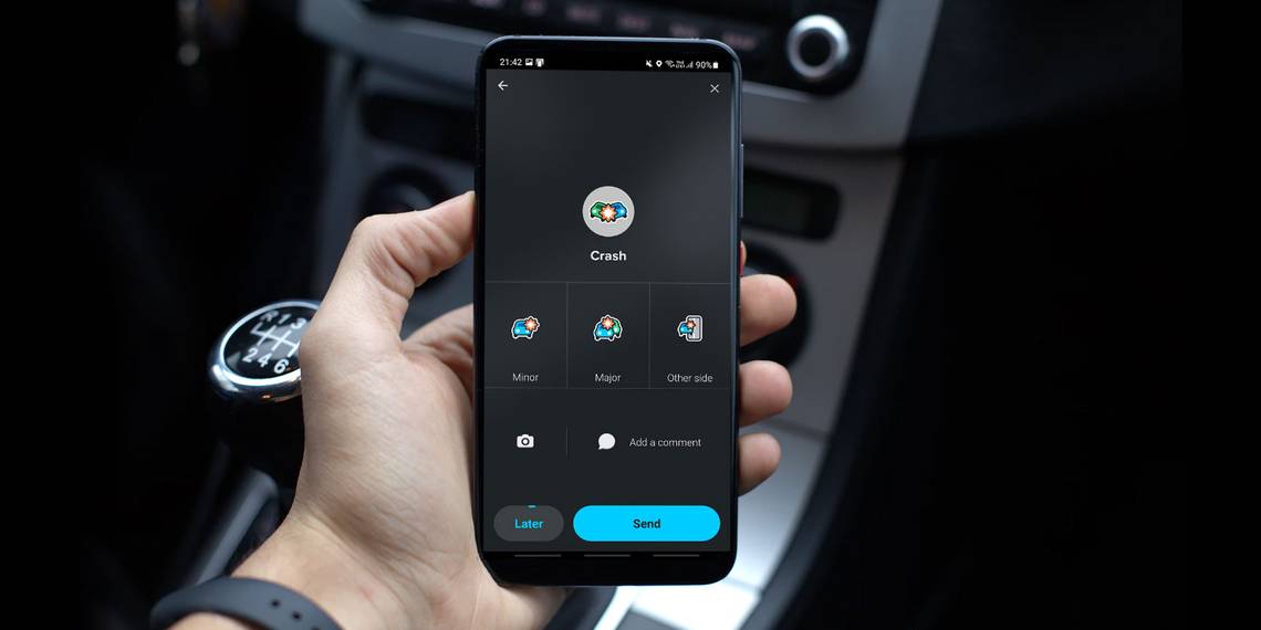
Finally, the crash icon allows you to report if there’s been an accident. You can choose between Minor (if it’s a fender bender, blocking only a small portion of the road), Major (if it blocks two or more lanes), and Other side (if it only causes traffic due to rubbernecking). Like the traffic report page, you can also add photographs or comments to your report.
Traffic Hazards


The Hazard icon lets you report to the community if something could cause potential issues, whether on the road, on the shoulder, or with the weather.
Road Hazards include objects, construction, broken traffic lights, potholes, stopped vehicles, and even roadkill. Shoulder hazards, could include stopped vehicles, animals, or missing traffic signs. Finally, if inclement weather affects the road, you can warn other drivers by reporting fog, hail, flooding, icy road conditions, or unplowed snowy roads.
Gas Prices


It’s prudent to save money, especially with gas prices skyrocketing nowadays. So, if you’re low on fuel and need to gas up, you can tap on the Gas Prices icon to see nearby stations. Waze will then pull up a list of nearby facilities.
When you tap on one, you’ll see the pump prices plus from when these prices were last updated. Furthermore, you can tap on Edit prices if the station has already changed the price or Confirm prices if they’ve stayed the same.
Map Chat


If you’re stuck in traffic or are a passenger in a slow-moving car, you can actually strike up conversations with fellow Waze users on the map. Just tap on the Map chat icon, tap on Add a comment, type your message, tap enter on the virtual keyboard, and then tap Send.
Your message will appear as a green icon on the Waze map that other Wazers can tap. They can leave comments on your message to drive a conversation.
Map Issues


While Waze is an excellent navigation app, it’s still not perfect when it gives directions. Sometimes, there’s a new traffic sign that the app isn’t familiar with yet. Other times, there might be a new development that Waze hasn’t mapped out yet, or maybe the store that your destination is pinned at has moved. You can use the Map Issue button to flag these problems to Waze.
Under Map Issue, you get two options: Map Issue and Pave.
Tap Map Issue to see these icons and issues you can report:
- General map error: A map problem that doesn’t fall under any categories below.
- Turn not allowed: Waze instructs you to turn left or right, but there’s a no-turn sign or there’s an obstruction blocking the path.
- Incorrect junction: The app shows an intersection, but it doesn’t exist in real life.
- Incorrect address: When you follow the directions correctly, but your destination isn’t there.
- Speed limit issue: Waze shows a different speed limit to the one indicated on the road.
- Missing bridge or overpass: The app indicates that you have to cross a river or intersection with a bridge, but it isn’t there.
- Wrong driving directions: You’re directed to travel against the flow of a one-way road.
- Missing exit: Waze asks you to exit the freeway, but no exit exists there.
- Missing road: The app shows a vehicular street on the map, but there is none in the real world.
If you encounter a new road that isn’t shown on Waze’s map, you can use Pave to map it yourself. Once you’ve reached the end of the new road or have returned to a mapped route, don’t forget to tap on Stop.
Place and Roadside Help


Once you reach a destination, you can photograph it for Waze to share with other users what they’re supposed to see when arriving at the pinned stop. To do so, tap on the purple Place icon.
A camera viewfinder will appear in the app, then all you have to do is point your phone at the pinned destination and press the camera icon. This will save the image in Waze’s database and make the location easier to find in the future.
If you run into car trouble and need assistance, you can request help from fellow Wazers. Tap on the Roadside help icon and then tap on Fellow Wazers. You can then pick any option, including Out of gas, Flat tire, Battery issue, Medical issue, or Other.
There’s also the Emergency call option, but it might not be available in all areas. If that is the case, don’t hesitate to dial the emergency number in your area directly—you don’t have to use Waze.
Road Closures


This is the bottom-most icon on the event report page, and it allows you to report road closures to other users. By doing so, you can inform other drivers to avoid the area and re-route while they’re still distant from the said closure.
When you tap on the Closure icon, you have three options: Hazard, Construction, and Event. Whatever option you choose, you’ll see a new window confirming how long the closure will be. You can pick between Less than 1 hr to Long term. And if you’re not sure, you can always choose Unknown.
Contribute But Drive Safely
You may notice that all functions have a Later option. This button allows you to save the location of the report on the app so you can complete reporting later. Always focus on your driving and don’t report anything in the moment if it will put you in danger.
But if you can safely do so, don’t hesitate to send your report. Because when you do so, this updates the information on Waze’s server, thus ensuring that all users will get an optimal path. That way, you can help make Waze a better navigation app for all.