I think there can be little doubt that writers here at MakeUseOf really love Google Maps and Google Earth. We've written about them extensively, such as John's Google Maps mashups article or Ann's article on historical mashups using Google Maps. There are a lot of really cool things that programmers can do with Google mapping tools.
This was the case over five years ago, and it's still the case today. Developers are constantly looking for new and innovative ways to integrate data with maps using the API tools offered by Google to utilize its maps in such mashups.
In recent years, it seems like the pace of development of these mashups haven't slowed down at all. In fact, there are more cool mashups and mapping tools offered by developers today than ever before. In this article, I'd like to highlight five more really cool uses dreamed up by developers for Google Maps and Google Earth.
Integrating Data Into Google Maps & Google Earth
For developers, Google Maps APIs give you a very effective way to take data that you may have stored on your own servers, such as location based information such as environmental data, server monitoring and alerts, or population and health information, and then integrate that data into a visual format on top of Google Maps.
This type of programming is beyond anything I've personally done, and I'm always amazed to see this development in practice. I'm sure the five examples below will impress you just as much as they impressed me.
Google Earth Weather
Tim covered it pretty well in 2010, but the quality and features of the Google Earth weather layer have only improved since then. You can access the Weather layer in Google Earth by enabling it in the left navigation bar under "Primary Database".

The weather layer is really impressive, with satellite images of clouds, actual real-time radar data, and even real-time temperatures. This layer in Google Earth can help you follow weather patterns all around the world. Get the weather even before the meteorologists give it to you!

When you zoom in, you get much more detailed imagery of clouds and radar, but you can also click on specific locations to get current weather details and even a weather forecast.

When you zoom in, you'll also see the temperatures listed right on the map, and images of clouds where there's current precipitation going on.
Tracking Your Location History
Years ago, I covered Google Latitude in one of its early versions, and about a year later Tim covered a few cool uses for Google Latitude, including using a mobile phone to create sort of a location-tracking log of your position over time in the form of tracks on top of Google Maps.

I've always liked this concept, but I never really felt like it was practical as long as I had to keep GPS enabled on my phone, because it seemed to drain down the battery so fast.
Another cool approach is actually a web-based app called Map My Day, under development by web developer Patrick Wied. The app isn't available for you to log in with an account and start mapping, but you can check out the demo that shows how this particular developer made use of Google Map's API to integrate location data from the visitor's browser.

When you click on "Check In", the app (with your permission) obtains your location and logs it on the map, and it starts a timer. Once you click "Check Out", the timer stops and your time at that location shows up at the bottom of the screen under "Tracked Timeslots".
This is actually a really cool geo-based journal - a way for you to look back in time to check where you were on a certain day, at a certain time and how much time you spent there. Let's hope Patrick is able to get this into a full-blown web application soon!
F-Secure BotNet Mapping
Other developers that made cool use of a Google Earth mashup with real data are the folks over at F-Secure. They've created a really interesting Google Map visualization that shows the spread of the Zero Access rootkit and the massive botnet created by those infections throughout the entire world.
The Google Earth mashup is presented in the form of visualization images at the F-Secure website. There are two images - one that shows the infections in North America, and one that shows them in Europe.

You can zoom into the map a bit to get a better grasp on just how massive the spread of this infection is.

When you look at the data in this way, it literally makes the spread of this computer virus look like the spread of an actual virus throughout the globe. It's sort of freaky when you look at it that way.
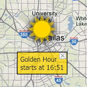
The Golden Hour
One of the most interesting uses of Google Maps that I can honestly say I've ever seen is an interesting website called the Golden Hour [Broken URL Removed].
The golden hour is defined as the one special hour - the first and last hour of sunlight - when sunlight tends to fall on objects in just the certain way and in just the right quality to create some of the most beautiful photographs ever taken.
Now, photographers looking for just the right outdoor lighting can use Golden-Hour.com to check what today's "Golden Hour" is.

You can change the location of the map with the Location dropdown list off to the upper right. The bottom of the map also displays sunrise and sunset times for today, as well as day length, twilight and more.
Google Follow Your World
I think one of my favorite uses of Google Maps comes from Google itself. It's a neat service called "Follow Your World", that lets you sign up to get imagery notifications from Google Maps.
What this means is that when you sign up for notifications from a certain location, Google will send you an email notification any time anyone posts new photos to Google Maps for the region of the world that you've registered for.

If you enjoy browsing through the photo layer of Google Maps for particular spots in the world, this feature is a really convenient way to stay on top of new photos from that area.
You can register for as many locations as you like, and manage those in a list on your Dashboard page.

As you can see, there's no shortage of creative uses for Google Map sand Google Earth, it really boils down to the creativity of the many skilled developers out there.
Have you ever come across any especially cool uses for Google Maps and Google Earth? Do you use any of the tools listed in this article? Share your own resources and feedback in the comments section below!