The Autobahn isn't the be all and end all of highways. The famous German highway system is riddled with speed limits -- yes, speed limits! -- traffic, and lack of space. If you desire more from a road trip than the occasional speed kick, enjoy the spacious lanes and stunning views of your local North American highways. Better yet, cut both the traffic and your gas bill and virtually enjoy these scenic drives from wherever you are. This is also a great option while some National Parks and Monuments remain closed during a government shutdown.
Below I present 5 iconic North American Highways, from North to South and West to East. Join me on a virtual road trip that will take you across the continent, from the comfort of your home.
How Does A Virtual Road Trip Work?
The best way to get a good impression of the scenery and navigate at your own pace, is to jump into Google Maps with Street View and fast forward yourself along the highway. Below is the average view of the Autobahn by the way. Notice the speed limit?

Alternatively, you can enter smaller legs of your virtual trip into a tool that creates an auto-guided Google Street View tour, such as the Google Maps Streetview Player. That's a great way to quickly gather impressions.

Finally, you can search YouTube for timelapse videos of your desired trip.
Of course I did all of that for you and included auto-guided tours, videos, and some other resources for the selected highways.
Trans Canada Highway
Where: from British Columbia to Newfoundland and Labrador
The Trans Canada Highway is the world's longest national highway, measuring 7,821 kilometers or 4,860 miles. It stretches from Victoria, British Columbia in the west to St. John, Newfoundland in the east. On its way from coast to coast, it cuts through temporal rain forest, winds along rivers, crosses the Rocky Mountains, and travels through prairies. Starting and ending on an island, it requires a ferry ride to cross the Pacific on one end and the Atlantic Ocean on the other end of the highway.

This iconic Canadian highway has its own website, TransCanadaHighway.com, as well as a mobile page, where you can read about the highway's history, browse tours and itineraries, and discover a host of other resources.
http://www.youtube.com/watch?v=2kCtIIcXErM
Further resources: Auto-guided tour & timelapse videos
Sea to Sky Highway
Where: between Vancouver and Whistler, British Columbia, Canada
The Sea to Sky corridor is the most scenic stretch on Highway 99. It runs from Vancouver to just north of Whistler, taking travelers from the Pacific ocean, to the Whistler ski resort, with stunning views of the Howe Sound and the Coast Mountains. To accommodate traffic, the highway was significantly upgraded for the 2010 Winter Olympics.

The Sea-to-Sky Highway doesn't have a pretty homepage. After the Improvement Project was completed in 2010, the respective website was decommissioned. However, it continues to link to webcams, stories, and more. Fortunately, many other resources featuring this scenic route are available, including a page on Hello BC, a weekend tour on Tourism Vancouver, a page listing all the interesting stops along the route on Info Vancouver, and a Twitter page with tweeple powered highway updates.
http://www.youtube.com/watch?v=oid4KZZ_3ns
Further resources: Auto-guided tour & timelapse videos.
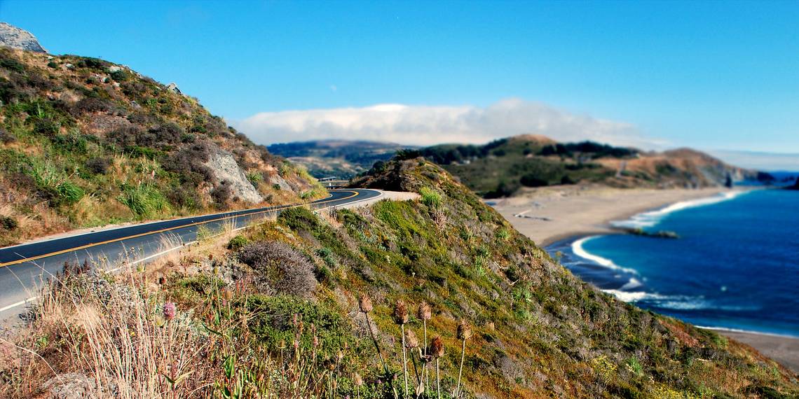
California State Route 1
Where: from Leggett to Dana Point, California
Route 1 is a legendary state highway that winds along California's coast. Arguably its most beautifl stretch runs through Big Sur, a sparseley populated area in the Santa Lucia Mountains between Monterey County and San Luis Obispo County. This area is famous for steep cliffs and breathtaking views of the ocean.

Countless webistes report on Route 1 or the Pacific Coast Highway, as it is called for part of its way. Wikitravel has some of the best information, National Geographic featured it in its Drives of a Lifetime series, and the Travel Channel features a photo series with views along the entire West Coast, from Washington in the north to California in the south.
http://www.youtube.com/watch?v=hnr1jwcGGB0
Further resources: Auto-guided tour & timelapse videos
Highway 12
Where: Panguitch in Garfield County to Torrey in Wayne County, Utah
Highway 12, also known as Scenic Byway 12, has been an All American Road since 2002. Over the course of its 124 miles (200 km), it runs through two national parks, Bryce Canyon and Capitol Reef, and passes many waypoints worth exploring.
http://www.youtube.com/watch?v=T0YzoFI10iw
Scenic Byway 12 has its own website (no longer available), which features an interactive map and many helpful resources for travelers. Utah.com has further details on the stops along the way.
Further resources: Auto-guided tour & timelapse videos
Overseas Highway
Where: Florida City to Key West, Florida
The Overseas Highway is part of US Route 1. Over 127.5 miles (205.2 km), it passes through the Florida Keys. Large parts were built using bridges of the former Overseas Railroad, which was not rebuilt after serious Hurricane damage in 1935. The modern highway opened in 1938, but partially existed in 1928, when ferries connected a 41 mile gap between its sections.
http://www.youtube.com/watch?v=tOakyE-pmb0
The highway has its own section on the Florida Keys & Key West website, National Geographic featured it in their Drives of a Lifetime series, on the Keys History page, you'll find a chapter on the History of the Overseas Highway and then there is a Stories From The Oversease Highway Facebook page.
Further resources: Auto-guided tour & timelapse videos
More Incredible Adventures
One article can only feature so many things. If you are eager to discover scenic drives close to your corner of the US, have a look at America's Byways, a page by the Federal Highway Administration or browse MyDrivelapse.com for timelapse videos of scenic drives from around the country.
Where Will Your Next Road Trip Take You?
Have you discovered something you must see for real? Where is your next road trip going to take you? And what routes can you recommend from your last? Please share your travel memories and plans in the comments!
Image Credits: Pacific Coast Highway Via Flickr, EditorASC via Wikimedia