
What happens when you combine the social networking power of Twitter with the usefulness of Google Maps? The result can be some pretty cool and intriguing applications.
The idea of a mashup in Web development is to simply take the data and functionality of different sources and combine them together to make a new service. With Twitter and Google Maps mashups here, it's all about taking advantage of both the Google Maps and Twitter API to create a mashup that's unique, practical, and fun.
Let's get right to it and find out what all the fuss is about. Here's 3 cool Twitter and Google Maps mashups you should check out.
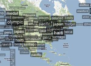
Trendsmap

Trendsmap is a tool to visualize the top Twitter trends throughout the world. Simply put, it's about what people are talking about right now and where they are. Just browse the globe for all the current hot discussions in any region of the world.
If you come across a topic that you'd like to explore further, just click on it for more information. Two small graphs of both the local and global history of that particular trend are displayed on top, along with details about why the topic is a big news story. Below that are links to any videos and news articles, followed by the most recent tweets about the topic continuously updated in real-time.

Feel free to explore the current Twitter trends in your region or city as well. Just zoom in on the map or type in your location for more of a local level perspective.
GeoChirp
Ever wonder what people in your neighborhood are tweeting about? GeoChirp allows you to easily find out with its mashup. Start by selecting a search radius anywhere on the Google map by simply clicking an area.

The latest tweets from that region will be displayed at the bottom of the map. You can then use the site's filter to specify a keyword, the number of tweets displayed, and the search radius (between 1 and 50 miles).

Keep in mind that the search results aren't updated automatically, so be sure to hit the refresh button for the latest tweets.
Twittervision
Twittervision is an interesting way to view tweets from all across the world. Once on the website, you don't have to do anything but watch aimlessly as you sweep across the globe for real-time Twitter updates.

It pauses to display a popup of the actual tweet from where it was sent, along with the Twitter user and location. After that, it just moves on to the next tweet. There's not much in terms of customization, but it's still a lot of fun.
If you get bored with that, give the website's 3D mode a whirl. It's the same concept, but this time it uses a three-dimensional globe from Poly9, not Google Maps. Twittervision is also available as an iPhone app.
Can't get enough of these? Be sure to check out 9 Awesome & Useful Google Maps Mashups for more.
Do you have any favorite Twitter and Google Maps mashups? Let us know in the comments.