Have you ever wondered how your favorite place used to look like 50 or 100 years ago? Would you like to refresh your childhood memories and find out what your native town looked like when you were a kid.
If "yes" is the answer to either of the questions, you'll find the three projects shared in this post quite exciting.
They have a few things in common: they all support Google Maps for you to easily find the place you are interested in. They all have Google Earth integrated for you to get the location 3D view and they allow users to upload old photographs of any geographical locations.
HistoryPin
Historypin [No Longer Available] (see previous MakeUseOf review of HistoryPin) is a global project created by the social movement We Are What We Do, in partnership with Google. The site works as a digital time machine, allowing people to view and share history online. According to the site creators, its mission is to get families back together to share memories and organize them using the site.
In essence, it's a community which means everyone can register to upload his old photo, locate the place on a Google Map and Google Street View and pin it. When uploading a photo you'll need to enter date and location which is required information.

You can also add stories behind your photographs (by sharing and discovering the stories behind your photos you'll be finding out about your own history - who you are and where you've come from). The "Stories" feature makes this site the most personal of all the three I share in the post:

To browse the photos and stories, you don't need an account (which is cool). The site has a very slick search engine that allows to search photos by:
- Location;
- Keyword;
- Year (with help of a pretty slider):

LookBackMaps
LookBackMaps [Broken URL Removed] (see MakeUseOf review of LookBackMaps) is another (probably less fun but still cool) way to visually organize, explore and engage in historical photographs through web.
The collection stored on the site was started by mapping the "millions of historical photos available through public libraries and private collections on the web". However, the creators do need help and do allow users to help them make their collection larger.
With help of this browser bookmarklet [Broken URL Removed] anyone can easily add historical photos to LookBackMaps - only photos already published on the web can be uploaded there. Any photo linked on LookBackMaps must have a source (this is to protect the original owner's copyrights). This means there is no tool to upload a photo directly from your desktop and you will have to upload it to some image hosting service (like Flickr or Photobucket) to add the photo to LookBackMaps gallery.
The search option allows you to locate historical places by a keyword (location) like on Google Maps - you can also use year checkboxes to filter your results by time:

Then just locate the LookBackmaps icon on a map, click it to see the old photo and go to "details" if you want to know more and compare with Google Street View result of the exact same place:

3. SepiaTown
SepiaTown (see MakeUseOf review of SepiaTown) lets you view and share "thousands" of mapped historical images from around the globe.
We built SepiaTown because we wanted anyone anywhere to be able to see the past in an instant.
The site does indeed have a huge collection of photos (with carefully cited sources for each one):

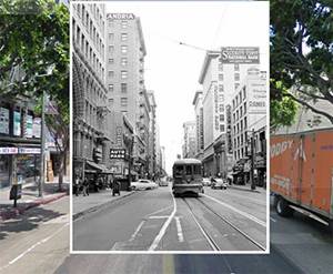
The NOW/THEN link switches to Google Street View to compare the historical place with how it looks now:

Each photo has notes with some historical and geographic information on it:

The Sepia Blog is also an awesome read and may take you quite some time to go through it. The blog shares the latest uploads, interesting finds and collects best historical photos by location.
Are there any other interesting historical Google Maps mashups? Please share them in the comments!